| Name |
|---|
|
خان بیلہ
Khanbeila
|
|
خان پور
Khanpur
|
|
لیاقت پور چولستان
Liaquatpur
|
|
رحیم یار خان
Rahim YAR Khan
|
|
صادق آباد
Sadiqabad
|
Loading content...
Loading content...
What does "Patrasab" mean?
Patrasab is a unique name that combines three important concepts in Pakistani land and family heritage. The name reflects our mission to connect land records with family genealogy.
Patwari
The Patwari is the traditional village land record keeper in Pakistan's revenue system. For generations, Patwaris have maintained land ownership records, crop registers, and property transfers. They are the custodians of land data at the village level.
Virasat
Virasat means inheritance or legacy. It encompasses what has been passed down through generations - property, land, values, and family heritage. Virasat represents the wealth and wisdom inherited from your forefathers.
Nasab
Nasab means family lineage or genealogy in Urdu/Arabic. It refers to your family tree, ancestral connections, and bloodline. Nasab represents who you are, where you come from, and how you're connected to your ancestors and relatives.
Bringing It All Together
Our Mission
Digitize the Patwari System: Bring traditional land records into the
digital age, making them accessible and easy to manage
Preserve Your Virasat: Ensure your family's land ownership history
and heritage are preserved for future generations
Build Your Nasab: Help families document their genealogy and connect
generations through comprehensive family trees
Connect Land to Family: Link property records with family relationships
to show who owns what, who inherited from whom, and how wealth flows through generations
What are the features of Patrasab?
Patrasab is a crowd-sourced land records management platform designed to help individuals, families, and communities organize, visualize, and analyze their land ownership information in Pakistan.
Core Features
Comprehensive Record Management
What you can manage:
- Kheewats: Track all ownership records with detailed owner information
- Khasras: Maintain individual plot records with area, classification, and irrigation type
- Ownership Changes: Record inheritance, sales, gifts, and transfers
- Property Details: Store location, boundaries, DC rates, and estimated values
Personal & Family Property Management
Organize property at multiple levels:
- Your Property: Manage all land parcels you personally own
- Immediate Family: Track property owned by your spouse, children, and parents
- Extended Family: Maintain records for uncles, cousins, and relatives
- Family Tree (Nasab/Shajra): Draw and visualize your family genealogy with property ownership mapped to each family member
Ownership History & Inheritance Tracking
Document the complete ownership journey:
- Record how property was acquired (inheritance, purchase, gift)
- Track previous owners and transaction dates
- Document sale prices and buyer information
- Maintain mutation (intiqal) records
- Generate reports like "How much land did my grandfather own?"
Visual Mapping & Spatial Analysis
See your land on maps:
- View Khasra Locations: Visualize plots on interactive maps
- Draw Boundaries: Manually draw and mark your Khasra boundaries
- Neighboring Properties: See adjacent plots and their Khasra numbers
- Area Visualization: Understand the geographic layout of your holdings
Neighbor & Adjacent Property Analysis
Analyze properties around yours:
- Identify all Khasras adjacent to your property
- Find out who owns neighboring plots
- View contact information of neighboring landowners (if shared)
- Analyze property values in your area
- Useful for expansion opportunities or resolving boundary disputes
Automatic Import from Tafseeli Khasra
Quick setup with document import:
- Upload your Tafseeli Khasra documents
- Patrasab automatically extracts owner information
- Auto-populates land records including Kheewat, Khasra, and area details
- Creates user accounts for property owners
- Saves hours of manual data entry
Property Valuation & Financial Analysis
Estimate property worth:
- Calculate estimated values based on DC rates
- Get Kheewat-level total valuations
- Individual Khasra valuations
- Compare values across different Mauzas
- Track property value changes over time
Integration with Nasab (Family Tree)
Connect genealogy with property:
- Link family tree members to their property holdings
- Generate inheritance reports showing land distribution across generations
- Visualize "How much land did my grandfather own and how was it divided?"
- Plan future inheritance distributions
- Understand family wealth accumulation over time
Common Use Cases
| Use Case | How Patrasab Helps |
|---|---|
| Inheritance Planning | Track all family properties, document ownership chains, and plan fair distribution |
| Property Purchase | Research neighboring properties, verify ownership, analyze market rates |
| Legal Disputes | Maintain clear ownership records, boundary documentation, and historical evidence |
| Agricultural Management | Track which plots are cultivated, irrigation types, and crop patterns |
| Family Record Keeping | Centralize all family land records in one accessible digital platform |
| Property Portfolio | Get overview of total holdings, estimated values, and geographic distribution |
Why Use Patrasab?
Centralized Records: All your land information in one place, accessible anytime
Family Collaboration: Multiple family members can contribute and access shared records
Historical Documentation: Preserve ownership history for future generations
Visual Understanding: Maps and charts make complex land holdings easy to understand
Quick Import: Save time with automatic document processing
Analytical Tools: Get insights about property values, ownership patterns, and trends
Open Platform: Community-driven data helps everyone make informed decisions
What is the mission of Patrasab?
Patrasab's mission is simple: Know your land, preserve your legacy, honor your roots. We're building a platform that empowers every Pakistani to understand, manage, and protect their family's land heritage.
Educate the Public
Pakistan's land system uses complex terminology that most people don't understand. Terms like Kheewat, Khasra, Khatuni, Mauza, and Tafseeli Khasra are confusing and rarely explained in simple language.
Our solution: We provide clear explanations, visual guides, and help documentation in both English and Urdu. We make land records accessible to everyone, regardless of their education level.
Simplify Complex Language
The language of land records is technical, legalistic, and intimidating. Terms are often in Urdu, English, and legal jargon mixed together. Most landowners struggle to understand their own property documents.
Our solution: We translate complex terms into everyday language. We use visual examples, real-world scenarios, and step-by-step explanations. Every technical term has a clear definition with practical examples.
Combat Land Fraud & Illegal Possession
Pakistan faces serious issues with land grabbing (qabza mafia), illegal possession, fraudulent documents, and disputed ownership. Many families lose ancestral land due to lack of proper documentation and awareness.
Our solution: We help you document and track your land ownership. When you have clear records of who owns what, when it was acquired, and from whom it was inherited, it becomes much harder for others to make false claims. Awareness is the first line of defense against land fraud.
Connect Disconnected Records
Pakistan's land records are fragmented. Each Mauza, Tehsil, and District maintains separate records with different systems. If you own land in multiple villages, you must visit multiple offices. There's no centralized way to view your complete land portfolio.
Our solution: Patrasab brings all your land records together in one place. Whether you own property in Lahore, Attock, or Karachi, you can manage everything from a single platform. We connect the disconnected, creating a unified view of your family's holdings.
Preserve Family Heritage
Families are losing their history. Elders pass away without documenting who inherited what. Property disputes arise because no one documented the inheritance chain. Future generations don't know their ancestral roots or land history.
Our solution: By combining Nasab (family trees) with land records, we help you document and preserve your family's story. Show your children: "This is the land your great-grandfather owned. This is how it was divided. This is your heritage."
Empower Communities
Land information shouldn't be locked away in dusty Patwari offices. Communities should have access to accurate, up-to-date information about land in their area.
Our solution: As a crowd-sourced platform, we believe in open data. When everyone contributes their knowledge, the entire community benefits. You can see who your neighbors are, understand property values in your area, and make informed decisions.
The Problem We're Solving:
| Current Problem | Patrasab Solution |
|---|---|
| Complex terminology no one understands | Clear explanations in simple language |
| Records scattered across multiple offices | All your records in one platform |
| Land fraud and illegal possession | Documented ownership creates protection |
| Lost family heritage and history | Preserved for future generations |
| Inheritance disputes | Clear documentation prevents conflicts |
| Difficult to manage multiple properties | Unified dashboard for all holdings |
What is Nasab?
Nasab (also called Shajra) is a family tree or genealogical record that documents your lineage, relationships, and ancestral connections. In Patrasab, Nasab helps you connect family members with their land ownership across generations.
Family Tree Structure
Nasab visualizes your family relationships showing parents, siblings, children, grandparents, and extended family members. Each person in your Nasab can be linked to their land holdings, creating a complete picture of family wealth and inheritance.
Generational Documentation
Track your family across multiple generations: Great-grandparents → Grandparents → Parents → You → Children → Grandchildren. Document births, marriages, and property transfers through the family line.
Relationship Mapping
Nasab establishes clear family relationships including:
- Direct lineage (father, mother, children)
- Siblings and half-siblings
- Extended family (uncles, aunts, cousins)
- In-laws and spouses
- Adopted or foster relationships
Land Ownership Connection
Every person in your Nasab can be linked to their property holdings. See who owns what land, track inheritance patterns, and understand how family wealth has been distributed over time.
Benefits of Building Your Nasab
View Family Land Records
Access land ownership information for your relatives. See which Kheewats and Khasras
belong to family members, understand total family holdings, and identify potential
inheritance.
Preserve Family Legacy
Document your family's history for future generations. Record names, dates, stories,
and property details that might otherwise be lost over time. Create a lasting digital
record of your ancestral heritage.
Track Inheritance Patterns
Understand how land was passed down through generations. See "How much land did my
grandfather own?" and "How was it divided among his children?" Answer inheritance
questions with documented evidence.
Build Complete Family Tree
Visualize your entire family structure. Connect with distant relatives, understand
complex family relationships, and discover branches of your family you may not have
known about.
Plan Future Inheritance
Use your documented family tree and land records to plan fair inheritance distribution.
Make informed decisions about property division based on complete family and ownership data.
Resolve Property Disputes
Having documented family relationships and ownership history helps resolve disputes.
Clear evidence of who inherited from whom can prevent or settle legal conflicts.
Collaborate with Family
Multiple family members can contribute to building the Nasab. Share knowledge,
verify information, and create a comprehensive family record together.
Discover Family Assets
Identify forgotten or unknown family properties. Find land parcels that may have
been overlooked, discover joint ownership opportunities, or locate inherited assets.
Visual Example:
| Generation | Family Member | Relationship | Land Holdings |
|---|---|---|---|
| 1st (Grandparents) | Abdul Rahman | Grandfather | Kheewat 45, 67 (150 Kanal) |
| Fatima Bibi | Grandmother | Kheewat 89 (20 Kanal) | |
| Property divided among 4 children | |||
| 2nd (Parents) | Muhammad Ashraf | Father (Son of Abdul Rahman) | Kheewat 156 (45 Kanal - inherited) |
| Ayesha Begum | Mother | Kheewat 178 (10 Kanal - dowry) | |
| 3rd (You) | Ahmad Ashraf | Son of Muhammad Ashraf | Kheewat 234 (15 Kanal - gift from father) |
How are land records organized within Pakistan's system?
Pakistan's land revenue system is organized in a hierarchical structure, from the smallest plot of land to the entire country. Understanding this hierarchy helps you navigate land records and know where to look for information.
Administrative Levels
Country
Pakistan - The entire nation, which encompasses all land records and revenue systems across the country.
Province
Pakistan is divided into provinces: Punjab, Sindh, Khyber Pakhtunkhwa (KPK), Balochistan, Islamabad Capital Territory (ICT), Gilgit-Baltistan, and Azad Jammu & Kashmir.
Each province has its own revenue authority and land administration system.
Example: Punjab, Sindh
Division
Provinces are divided into administrative divisions for governance purposes. A Division oversees multiple districts.
Example: Rawalpindi Division, Lahore Division, Multan Division
District
A District is the primary administrative unit under a Division. Each district has its own Deputy Commissioner (DC) who oversees revenue collection and land administration.
The DC Rate (property valuation rate) is set at the district level.
Example: Attock District, Lahore District, Karachi District
Tehsil
Districts are subdivided into Tehsils. A Tehsil is the key administrative unit for land records, headed by a Tehsildar. Most revenue offices (Tehsil Municipal Administration) operate at this level.
When you need official land documents, you typically visit the Tehsil office.
Example: Hazro Tehsil (in Attock District), Cantt Tehsil (in Lahore)
Qanoongoi
A Qanoongoi is a grouping of several Mauzas (villages) under one revenue jurisdiction. It's an administrative cluster that helps organize land records for nearby villages.
Multiple Mauzas belong to one Qanoongoi, and multiple Qanoongois form a Tehsil.
Example: One Qanoongoi might include 5-10 neighboring villages
Halqa Patwari
A Halqa Patwari is the area assigned to one Patwari (village record keeper). One Patwari may be responsible for maintaining land records of one or more Mauzas.
This is the operational unit where the Patwari actually works and maintains records.
Example: A Patwari might manage records for 2-3 small villages
Mauza
A Mauza is a revenue village or the smallest geographic land unit. This is where actual land records (Kheewats, Khasras) are maintained.
Every piece of land belongs to a specific Mauza. All land ownership is tracked at the Mauza level.
Example: Shams Abad (Mauza), Tajak (Mauza)
Land Record Documents & Identifiers
Kheewat
Owner-based record. A unique identification number assigned to landowner(s) within a Mauza. All plots owned by the same person/people in one Mauza are grouped under one Kheewat number.
Think of it as: Your "owner ID" for a specific village.
Example: Kheewat No. 156 - Muhammad Ashraf owns 3 plots in Shams Abad
Khasra
Plot-based record. A unique survey number assigned to each individual piece of land within a Mauza. Every plot, no matter how small, has its own Khasra number.
Think of it as: The "plot number" or "address" of your land.
Each Khasra record contains: area (K-M-F), boundaries, classification, irrigation type, and ownership details.
Example: Khasra No. 234 - A specific 10 Kanal plot in the village
Khatuni
Cultivator-based record. Identifies who is actually farming/cultivating the land, which may be different from the owner.
Think of it as: The "farmer ID" - who's working the land.
Important for tenancy arrangements, leases, and sharecropping. Recorded during Girdawari (crop inspection).
Example: Khatuni No. 89 - Ali Hassan cultivates land owned by someone else
Jamabandi
Consolidated revenue record. Also called "Fard Jamabandi," it's a comprehensive register that compiles all land information for a Mauza, including ownership, cultivation, crops, and revenue.
Think of it as: The "master ledger" of all land in the village.
Updated annually and contains: Kheewat, Khasra, owner names, cultivator names, area, land classification, crops grown, and revenue due.
This is the main document you request when getting official land records
Charsala
Four-year crop register. A historical record that documents crop patterns and cultivation over four agricultural years (two Rabi and two Kharif seasons).
Think of it as: The "agricultural history" of your land.
Shows what crops were grown, by whom, and when. Useful for agricultural loans, crop insurance, and verifying cultivation patterns.
Example: Shows that wheat was grown in 2020, 2021; sugarcane in 2022, 2023
Visual Hierarchy Chart:
| Level | Name | Urdu | What It Contains | Example |
|---|---|---|---|---|
| 1 | Country | ملک | All provinces | Pakistan |
| 2 | Province | صوبہ | All divisions | Punjab |
| 3 | Division | ڈویژن | All districts | Rawalpindi Division |
| 4 | District | ضلع | All tehsils | Attock |
| 5 | Tehsil | تحصیل | All qanoongois | Hazro |
| 6 | Qanoongoi | قانون گوئی | Group of mauzas | Qanoongoi Shams Abad |
| 7 | Halqa Patwari | حلقہ پٹواری | Patwari's jurisdiction | Halqa 25 |
| 8 | Mauza | موضع | All kheewats & khasras | Shams Abad |
| 9 | Kheewat | خیوت | Owner's plots | Kheewat 156 |
| 10 | Khasra | خسرہ | Individual plot | Khasra 234 |
| 11 | Khatuni | کھتونی | Cultivator record | Khatuni 89 |
Key Documents Summary:
| Jamabandi | Complete revenue record - the main document with all ownership info |
| Fard Malkiat | Ownership certificate - proves you own the land |
| Tafseeli Khasra | Detailed plot record - all information about specific khasras |
| Girdawari | Crop inspection report - documents what's being cultivated |
| Charsala | Four-year crop history |
| Mutation (Intiqal) | Record of ownership transfer |
What is a Mauza?
Mauza is a revenue village or land unit used in Pakistan's land administration system. It represents the smallest geographic unit for maintaining land records.
Geographic Unit
A Mauza is typically a village or a distinct area within a larger administrative division. Each Mauza has defined boundaries and contains multiple plots of land (Khasras).
Administrative Hierarchy
Mauza sits within the revenue hierarchy: Province → Division → District → Tehsil → Mauza → Khasra (individual plot). All land records are maintained at the Mauza level.
Land Record Management
Each Mauza has its own complete set of land records including:
- Kheewat numbers (owner records)
- Khasra numbers (plot identification)
- Khatuni numbers (cultivator records)
- Fard Jamabandi (revenue registers)
Unique Identification
Every Mauza has a unique name and number within its Tehsil. The same land owner can have different Kheewat numbers in different Mauzas.
Visual Example:
| Tehsil | Mauza Name | Total Kheewats | Total Khasras |
|---|---|---|---|
| Hazro | Shams Abad | 123 kheewats | 1,234 khasras |
| Hazro | Tajak | 215 kheewats | 2,156 plots |
What is a Kheewat?
Kheewat is a unique identification number assigned to land owner(s) in Pakistan's land revenue records (Patwari system).
Owner-Based System
All plots (or khasras) owned by the same person/people in one village share one Kheewat number.
Village Specific
Kheewat numbers are specific to each village (mauza). If you own land in multiple villages, you'll have different Kheewat numbers for each.
Where to Find It
- Fard Jamabandi
- Fard Malkiat
- Registry/Sale deed documents
- Patwari or Revenue Office records
Visual Example:
| Kheewat No. | Owners Name | Plots/Khasras Owned | Total Area |
|---|---|---|---|
| 156 |
Muhammad Ashraf Junaid Khan |
234, 567, 891 | 45-23-450 |
What is a Khasra?
Khasra is a unique plot number assigned to each individual piece of land within a Mauza (village). It's like a "house number" for agricultural land.
Plot Identification
Each plot of land, no matter how small or large, is given a unique Khasra number. This number identifies the exact physical location of the land on the ground.
Survey-Based System
Khasra numbers are assigned during land surveys and are marked on survey maps (Shajra). These numbers remain permanent and help identify boundaries between adjacent plots.
Contains Detailed Information
Each Khasra record includes:
- Plot number and area (in Kanal-Marla-Feet)
- Owner's name and Kheewat number
- Land classification (Aabi, Chahi, etc.)
- Current cultivation details
- Boundaries (neighboring Khasra numbers)
Can Change Ownership
While the Khasra number stays the same, the owner (Kheewat) can change through sale, inheritance, or gift. The plot number remains constant regardless of ownership changes.
Visual Example:
| Khasra No. | Area (K-M-F) | Owner (Kheewat) | Classification | Current Crop |
|---|---|---|---|---|
| 234 | 10-5-100 | Muhammad Ashraf (Kheewat 156) | Aabi | Wheat |
| 567 | 20-10-200 | Muhammad Ashraf (Kheewat 156) | Chahi | Sugarcane |
What is a Khatuni?
Khatuni is a cultivator identification number in Pakistan's land records. It identifies who is actually farming/cultivating the land, which may be different from the owner.
Cultivator-Based System
While Kheewat identifies the owner, Khatuni identifies the cultivator (the person who is actually farming the land). One person can be both owner and cultivator, or they can be different people.
Tenancy Arrangements
Common scenarios where Khatuni differs from Kheewat:
- Lease/Rent: Owner leases land to tenant farmer
- Sharecropping: Cultivator shares crops with owner
- Contract farming: Temporary cultivation rights
- Self-cultivation: Owner farms their own land (same Kheewat & Khatuni)
Recorded in Girdawari
Khatuni information is updated during the bi-annual Girdawari (crop inspection) conducted by the Patwari. This records who is cultivating what crops on each Khasra.
Legal Importance
Khatuni records are important for:
- Agricultural loan applications
- Crop insurance claims
- Subsidy distribution
- Tenancy disputes
Visual Example:
| Khasra | Owner (Kheewat) | Cultivator (Khatuni) | Arrangement |
|---|---|---|---|
| 234 | Muhammad Ashraf (156) | Muhammad Ashraf (89) | Self-cultivated |
| 567 | Muhammad Ashraf (156) | Ali Hassan (92) | Leased to tenant |
| 891 | Junaid Khan (157) | Muhammad Ashraf (89) | Cultivating others' land |
How is land classified and irrigated?
Land in Pakistan is classified based on usage and irrigation source. Understanding these classifications is crucial for land valuation and taxation.
Irrigation Types
Aabi - Canal Irrigated
Land irrigated by government canals or flowing water channels. Most productive and valuable agricultural land. Regular water supply throughout the year.
Chahi - Well Irrigated
Land irrigated by wells or tube wells using groundwater. Second most productive. Requires investment in pumping equipment and electricity/diesel costs.
Nul Chahi - Canal + Well
Land with both canal and well irrigation. Most reliable water supply. Farmers use canal water when available and supplement with well water when needed.
Maira - Rain-fed/Barani
Land that depends entirely on rainfall. No canal or well irrigation. Less productive and riskier. Common in areas without irrigation infrastructure.
Sailabi - Flood Irrigated
Land in river flood plains that gets irrigated by seasonal flooding. Fertile soil but unpredictable water supply. Crop timing depends on floods.
Land Classification Types
Cultivable Land
Agricultural land with different irrigation sources: Aabi, Chahi, Nul Chahi, Maira, Sailabi (explained above)
Barren Land
| Banjar Qadeem | Old barren land - Uncultivated for more than 5 years, difficult to reclaim |
| Banjar Jadeed | New barren land - Temporarily uncultivated (less than 5 years), can be reclaimed |
Built-up/Developed Land
| Residential | Land designated for housing and residential purposes |
| Commercial | Land for business, shops, markets, and commercial activities |
Uncultivable Land - Ghair Mumkin
Land that cannot be used for cultivation due to specific purposes:
| Ghair Mumkin Road | Roads and pathways |
| Ghair Mumkin Masjid | Mosque land |
| Ghair Mumkin Madrassa | Religious school land |
| Ghair Mumkin Qabristan | Graveyard/Cemetery |
| Ghair Mumkin School | School/Educational institution land |
| Ghair Mumkin Naala | Water channel/drain |
| Ghair Mumkin Rasta | Pathway/footpath |
| Ghair Mumkin Kassi | Small path/track |
| Ghair Mumkin Tubewell | Tube well site |
Forest/Grazing Land
| Jungali Darakhtan | Forest land with trees, used for grazing or timber |
What is DC Rate?
DC Rate (Deputy Commissioner Rate) is the official property valuation rate set by the government for calculating stamp duty and registration fees on property transactions.
Government Valuation
The Deputy Commissioner (DC) of each district publishes official rates for land in different areas. These rates represent the minimum value at which property must be registered for tax purposes.
Used for Tax Calculation
DC Rates are used to calculate:
- Stamp Duty: Tax on property transfer documents
- Registration Fee: Fee for registering property in buyer's name
- Capital Gains Tax: Tax on profit from property sale
- Withholding Tax: Advance tax deducted at source
Location-Based Rates
DC Rates vary significantly based on:
- Location: Urban vs rural, tehsil, mauza
- Road Access: Main road, link road, or off-road
- Land Type: Residential, commercial, or agricultural
- Development: Developed vs undeveloped areas
Market Value vs DC Rate
Important: DC Rate is usually lower than actual market value. Properties typically sell for 2-3 times the DC Rate or more, depending on the area.
Regular Updates
DC Rates are typically updated annually or bi-annually by the district administration. Check the latest notification from your district's revenue department for current rates.
Location Categories
Properties are often classified by road access for DC Rate purposes:
| Main Road | Highest DC Rate - Property directly on major roads |
| Link Road | Medium DC Rate - Property on connecting/secondary roads |
| Off Road | Lower DC Rate - Property in interior areas without direct road access |
Calculation Example:
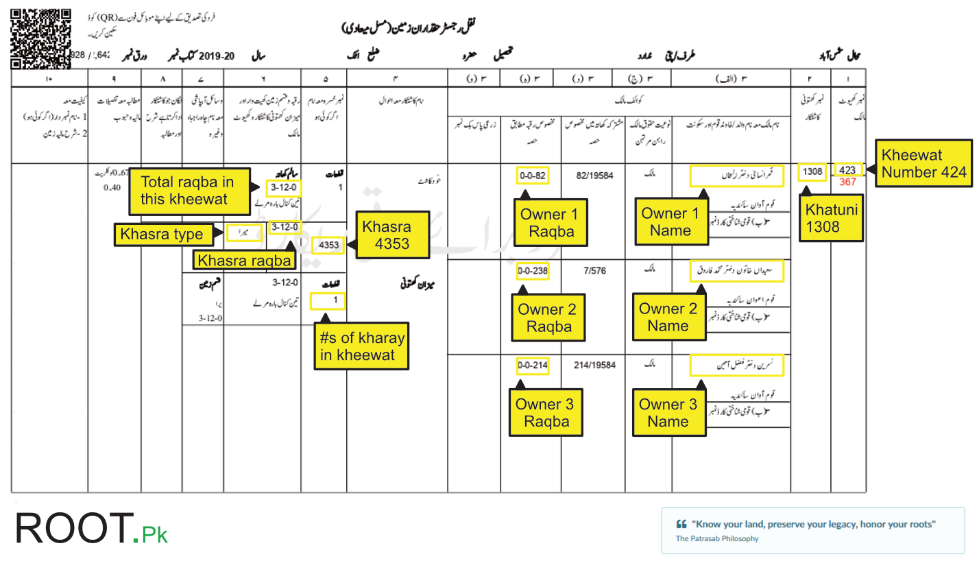
What is a Tafseeli khasra and how to read it?
Tafseeli Khasra means "Detailed Plot Record" in Urdu. It is a comprehensive document that contains complete information about individual land plots (Khasras) within a Mauza, including ownership, area, classification, and cultivation details.
Comprehensive Land Document
While a regular Khasra number simply identifies a plot, Tafseeli Khasra provides the full story of that land - who owns it, how big it is, what type of land it is, how it's irrigated, what's being grown, and its complete history.
Think of it as: A complete biography of your land plot.
What Information Does It Contain?
Tafseeli Khasra includes detailed information about each plot:
Khasra Number: Unique plot identification number
Kheewat Number: Owner identification number
Owner Details: Name, father's name, CNIC (if available)
Raqba (Area): Land size in Kanal-Marla-Feet format
Land Classification: Type of land (Aabi, Chahi, Maira, etc.)
Irrigation Type: How the land is watered
Khatoni Number: Cultivator identification
Cultivation Details: Current crops, Rabi/Kharif season
Boundaries: Adjacent Khasra numbers (North, South, East, West)
Revenue Information: Land revenue (lagaan) amount
Ownership History: Previous owners, mutations (transfers)
Remarks: Any special notes or conditions
Legal Importance
Tafseeli Khasra is an official government document that serves as legal proof of:
- Land ownership and ownership shares
- Property boundaries and size
- Land classification and usage rights
- Cultivation status and tenant rights
It's essential for property transactions, inheritance cases, agricultural loans, and legal disputes.
Difference from Other Documents
| Fard Malkiat | Shows only ownership - who owns the land |
| Fard Jamabandi | Annual revenue record for all plots in a Mauza |
| Tafseeli Khasra | Complete detailed information about specific plots |
| Girdawari | Crop inspection report - what's currently being grown |
When is it Updated?
Tafseeli Khasra is updated:
- Annually: During the annual Jamabandi (revenue settlement)
- After Mutations: When ownership changes through sale, inheritance, or gift
- During Girdawari: When crop inspections reveal changes in cultivation
- Upon Request: When corrections or updates are officially requested
Where to Get Tafseeli Khasra?
You can obtain Tafseeli Khasra from:
Patwari Office: Local revenue official maintains these records
Tehsil Office: Tehsildar or revenue department
Online Portals: Some provinces offer digital access (e.g., Punjab Land Records Authority - PLRA)
E-Khidmat Centers: One-stop service centers in Punjab
Required Information: You need to provide the Mauza name, Tehsil, District, and either Kheewat or Khasra number.
Associated Fees
There may be nominal fees for obtaining Tafseeli Khasra documents, varying by province and whether you get it from the Patwari or official revenue office. Digital copies from online portals are often free or low-cost.
Sample Tafseeli Khasra Structure:
| Field | Example Value | Urdu |
|---|---|---|
| Khasra Number | 234 | خسرہ نمبر |
| Kheewat Number | 156 | خیوت نمبر |
| Owner Name | Muhammad Ashraf s/o Abdul Rahman | مالک کا نام |
| Raqba (Area) | 10-5-100 (10 Kanal, 5 Marla, 100 Sq Ft) | رقبہ |
| Classification | Aabi (Canal Irrigated) | آبی |
| Khatoni Number | 89 | کھتونی نمبر |
| Cultivator | Muhammad Ashraf (Self-cultivated) | کاشتکار |
| Current Crop | Wheat (Rabi Season) | فصل |
| Boundaries | N: 233, S: 235, E: 236, W: 237 | حدود |
| Revenue | Rs. 2,500 per year | لگان |
Why is Tafseeli Khasra Important?
Property Transactions
Essential for buying/selling land - buyers verify ownership and details before purchase
Inheritance Cases
Proves ownership history and helps divide property among legal heirs
Agricultural Loans
Banks require Tafseeli Khasra to verify land ownership before granting loans
Legal Disputes
Court cases need detailed land records to establish boundaries and ownership
Property Valuation
Area, classification, and location details help determine market value
Development Projects
Government needs detailed land records for infrastructure and development planning
Patrasab's Tafseeli Khasra Import Feature
How to Manage land and nasab using Patrasab?
Patrasab is a crowd-sourced land records management platform designed to help individuals, families, and communities organize, visualize, and analyze their land ownership information in Pakistan.
You can read about it here.